


: Era Town, Nguyen Luong Bang,Phu My Ward, District 7, Ho Chi Minh City
028 66843500
+886 956918888
hotline
028 66843500 +886 956918888

Major Changes to Vietnam's Land Use Rights Certificate: Effective August 1, 2024

Post Date : Saturday, August 10, 2024

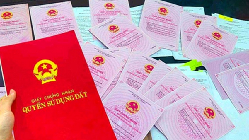
Starting August 1, 2024, Vietnam's Ministry of Natural Resources and Environment will enforce significant changes to the Land Use Rights Certificate, commonly known as the Red Book or Pink Book. These changes, outlined in Circular 10/2024/TT-BTNMT, aim to modernize the certificate's design and enhance its functionality, reflecting the evolving needs of land administration.

New Design and Content of the Certificate

The updated certificate will have dimensions of 210mm x 297mm, featuring a pink background with traditional Vietnamese drum patterns. This design choice underscores the official and legal nature of the document while incorporating elements of Vietnam's cultural heritage.

First Page Details

The first page of the certificate is meticulously designed to include several key elements:

  • National Emblem and Title: The national emblem and the title "Land Use Rights Certificate and Land-attached Asset Ownership Certificate" are prominently displayed in red, signifying the document's legal authority.
  • QR Code and Certificate Number: A QR code is placed in the top right corner, allowing for easy access to detailed information about the certificate. The unique certificate number ensures the document's individuality and traceability.

The first page is divided into three main sections:

  1. Land User and Land-attached Asset Owner Information: This section records the detailed identity of the certificate holder, ensuring the legality of their rights.
  2. Land Plot Information: Specific details about the land plot, such as its location, size, and purpose, are included, which are crucial for land management and usage.
  3. Land-attached Asset Information: This section describes the properties or assets attached to the land, including their legal status.

Additionally, the location, date, and issuing authority of the certificate are clearly indicated on this page, confirming the document's validity. The certificate's issuance number is also displayed, enabling tracking and documentation of each certificate issued. A note at the bottom of the page informs readers that more detailed information can be accessed via the QR code.

Second Page Details

The second page focuses on technical information and legal updates regarding the land and its attached assets:

  1. Land Plot and Attached Asset Diagram: This section visually represents the layout and boundaries of the land and attached assets, which is essential for identifying the property's location and extent.
  2. Notes: This section typically includes special legal clauses or additional information related to the land, such as usage restrictions or obligations.
  3. Post-issuance Changes: Any changes in ownership, land use, or other legal updates that occur after the certificate is issued are recorded here to ensure the information is up-to-date and accurate.

The certificate's registration number and related reminders are also displayed on this page for easy reference and verification.

Incorporating Modern Technology in Land Management

The Circular mandates that the printing of Land Use Rights Certificates must be done through modern land database management software. In regions where a complete land database has not yet been established, registration information must still be entered into the management system to ensure all certificates are generated and managed through a unified technological platform.

Additionally, the certificate's text formatting is strictly regulated. Titles and headings will be printed in "Times New Roman, Bold" font, size 13, while detailed content will use "Times New Roman, Regular" font, with a minimum font size of 12. The names of land users and asset owners will be printed in bold, with a minimum font size of 13, and all letters and numbers will be in black.

QR Code Application and Technical Standards

The introduction of QR code technology in the new certificate is a notable innovation. The QR code will store and display detailed information about the certificate, including the legal status of the land plot, owner information, and any changes. The information accessed through the QR code will have the same legal validity as the printed certificate and will align with the data in the land database.

The QR code must be generated and printed using the local government's land database management software and must comply with Vietnam's QR code technical standards (TCVN 7322:2009). For first-time printed certificates, the QR code will be located in the top right corner of the first page. If there are any changes to the information after the certificate is issued, the QR code will be displayed in the top right corner of the second page's "Information Changes and Legal Basis" section.

These updates and new regulations represent a significant step forward in Vietnam's land management practices, enhancing transparency, protecting the legal rights of landowners, and promoting the stability of the land market. For Taiwanese readers, this not only highlights the latest developments in Vietnam's land management policies but also provides valuable insights for policy-making in related fields.

 "Major Changes to Vietnam's Land Use Rights Certificate: Effective August 1, 2024"


Thank you for rating
0 0

Free Consultation Update the latest information
Enter your information to receive our advice
capcha
capcha
News Update the latest information
Ho Chi Minh City Faces a Shortage of Affordable Rental Housing
Dong Nai is making a strong breakthrough, emerging as a new urban hub.
2026 社會住宅「大浪潮」:數萬戶新住宅同步啟動建設
When Infrastructure Meets Incentive Policies: Where Is the New Focus of Capital Flow?
Billion-Dollar Infrastructure Takes Shape, Positioning Dong Nai as a New Investment Hotspot!
Dong Nai Transforms Rapidly as Investors Rush to Capitalize on Infrastructure Growth Opportunities!
More Than $1 Billion Flows into the North of Ring Road 4 – Is a New Growth Hub Taking Shape?
Enhancing Land-Use Efficiency: Ho Chi Minh City Reclaims Project Land in the High-Tech Park
Infrastructure Breakthrough: Direct Connection Between Ho Chi Minh City and Vung Tau via the New Expressway
Vietnam Strengthens Its Position on the APAC Economic Map, Creating Major Opportunities for the Real Estate Market.
Video clip Update the latest information